Wednesday, May 26, 2010

Alaska Expedition 2010 - Day 12 FAIRBANKS AT LAST (May 23, 2010)

Michelle picked us up at 8am and took us to her favorite bagel shop for breakfast.  She is a riot!  I love her sense of humor!  And, let me tell you, Alaskans make the BEST coffee!  A local company called the Kaladi Brothers Coffee, roast their own here in Alaska, and it is so good, that I bought a bag and had it ground.  Rafael and I have been making this coffee for breakfast every morning with the awesome french press Dylan and Bekah gave me for Xmas.  Best coffee I've ever had!


After breakfast, Michelle gave us a tour of campus, showing us where we would be teaching, where the bookstore is, the rec center, etc .  The campus is huge!  We drove out of town a little way to where the Alaskan Pipeline is near the road.  I didn't realize that it is as long as it is!  Plus, it's huge!


The pipes are built on these struts that allow movement of 12ft in one direction and about  2ft in the other, to accomodate the shifting permafrost beneath the pilings.  Very cool.

Our tour took us to Creamers Field, which is an old Dairy Farm that has been converted to a Wildlife Refuge for migrating birds.  We were thrilled to see Sand Hill Cranes eating in the field!


We drove over the the Alaska Bird Observatory, where they were holding a "Big Sit", and walked out to the pond and met some of the local birders.  What great people!  Dave was in his element, and I don't think I'm going to see him much this summer at all.  I think he'll be heading down to the banding station every morning before class! 

Michelle showed us where all the major "box" stores are:  Walmart, Barnes & Nobles, Home Depot, etc.  We even went into Barnes and Nobles because we still haven't found a book on the trees of Alaska.  Thankfully, they had one there!  I don't think Michelle intended to so much of the day with us, but she happily took us to some of the popular tourist stops, and told us which stores were good, and which ones to avoid.  At about 1pm, she dropped us back at home.  What a great day and what a neat lady.  She even told me where the wool shop is!!!  Plus, she says she can get me a bicycle to ride!  Is this heaven or what?!


Saturday, May 22, 2010

Alaska Expedition 2010 - Day 11 (May 22, 2010)


Tok, Alaska – pronounced toke - We got up at 5:30am to a bright sunny day. Temperature is in the 40’s F. The bed was super comfy, and I slept great. I really like these cabins, and I like it that cabin #4 has a ramp to the door, so that it is whellchair accessible. Our cabin has a queen size bed and a single bed on the main floor and two double beds up in the loft. There is a fridge, freezer, microwave and pretty blue stonewear cups and saucers. There are little decorative touches that make the place very homey.  Rafael and I walked over to the office and grabbed some breakfast, while Dave ate leftover pizza from last night's dinner.


Last night, after eating yummy chocolate cupcakes that Hannah and Holly had helped their mom, Carrie ice, Dave and I went for a walk in search of grouse.


Along every road here is a snowmobile/quad runner lane. We walked up Borealis Lane toward the Tok Cutoff and then turned N into the boreal forest. It is so cool and peaceful in the forest. The mossy forest floor, called muskeg is spongy when you walk on it. There are no short little trees or shrubs growing beneath the tall skinny spruce trees. We see a snowshoe hare scamper across the road. I have to take a picture of Dave, because he is walking through the Boreal Forest wearing a Tshirt that says "The Boreal Forest" from International Migratory Bird Day! 


Every once in a while, we see a patch of lichen on the forest floor.  It is so cool, because it looks like leaf litter!


Dave shows me a tree stump that is surrounded with pine cone scales, where red squirrels will perch and eat. We also see moss flowering (for Hickey). It is fascinating. If you look closely, the moss has tiny little red nubs where the new leaves(?) come out, then there are these 3inch-ish vertical spires pointing toward the sky. I love the smell of the forest.

There is a noticeable change in road conditions and housing when you cross into Alaska from the Yukon. Homes and businesses are more modern and the roads are in really good condition. We can drive 65mph with ease. Tok is 93 miles from the Canadian border and is a trade center for the nearby Athabascan villages. Some say that Tok’s name derives from the native word meaning ”peace crossing”, but others say Tok was the name for a survey crew’s dog. Still others say the name Tok comes from the native word “Tokai” which means “creek”. Tok claims the title of “Dog Capital of Alaska”, as it is a center for dog breeding, training and mushing.
The town of Tok began as a construction camp during the building of the Alaska Hwy. Today, it is also the only town in the interior of Alaska through which visitors driving to and from the state have to pass twice. There is no road leaving the interior that doesn’t pass through Tok on its way to the Yukon border at Beaver Creek or Boundary.
As we head north on the Alaskan Highway, we are amazed to see over 20 Snowshoe Hares within the first 5 miles of road. It is also funny to see the mile markers on poles that are 12ft high. They must get a helluva lot of snow here! At Robertson River, we stop on the bridge to take a picture of the ice that is still covering most of the river. It must be 10 feet thick in some areas.


 I can see that same soft blue color in the ice that I remember from the glaciers in Kenai Fjords outside of Seward, AK in 2002. The river is named for Sergeant Cady Robertson, who helped map Alaska. We see a moose trot into the woods and many Swainson’s Thrush zipping across the road. It really surprises me to see Robins up here too. I don’t think of them as arctic birds, but they are everywhere.
I find it very interesting to see the tree line along the mountains to our left (West). I thought that the tree line was a result of the top of the mountain consisting of just rock, and no dirt. But, the lack of trees on the mountain is due to more than just a lack of soil. Elevation, a short growing season and a lack of microbes in the soil all contribute. There are some trees, but they are very short and few and far between. We are still travelling through Boreal Forest along the highway, and the trees here are Trembling Aspen, Balsam Poplar, Felt-leaved Willow, Alaska Paper Birch, Speckled Alder, Subalpine Fir, White Spruce, Black Spruce (which I find so ugly), Tamarack and Lodgepole Pine.
At the next bridge, we see an Osprey perched on a snag in the middle of the river bed. Very cool.


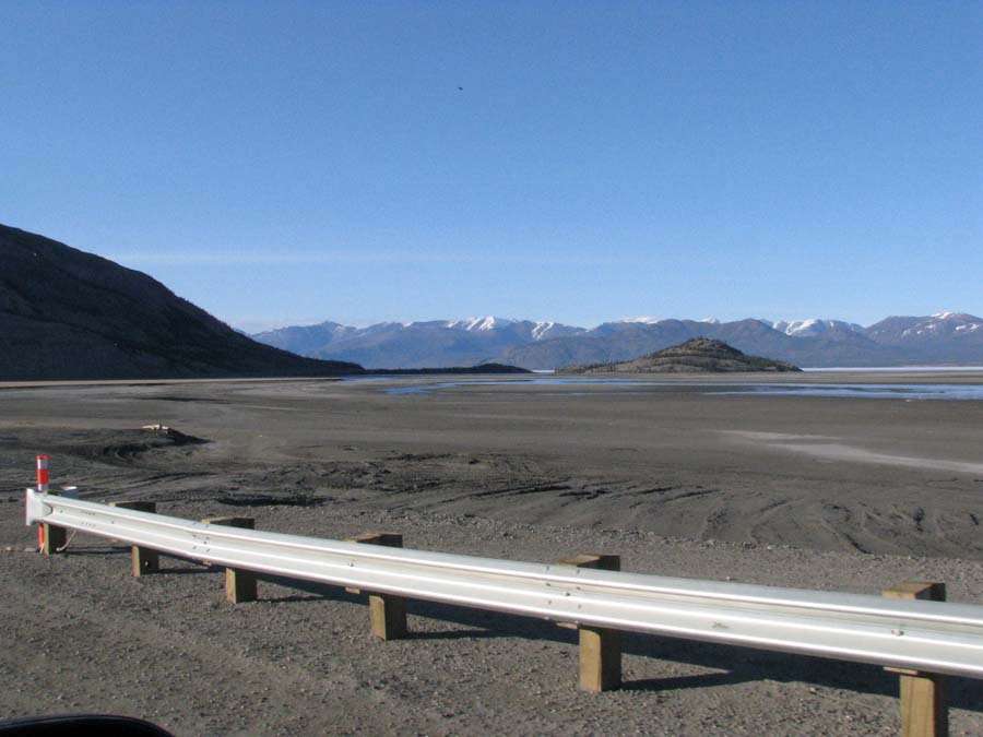
The river is almost dry with just a few tendrils of water making their way from the mountain toward the Tanana River. At the Gerstle River bridge, we see someone on a quad runner driving the dry river bed – yet the bridge is very long and the river bed is very wide. I can imagine this river full of water, once the snows melt.  As we get within 20 miles of Fairbanks, we see Mt McKinley in the distance to our left.  Most of the time, the mountain is shrouded by clouds, so we quickly pull over and snap a few photos!


While taking the pictures of the mountain, Dave yells that there is an eagle flying right below us!


Fairbanks, Alaska:  We arrive in Fairbanks a little before 11am, and follow the signs to UAF and the “Really Free Market”.


Once there we asked someone to direct us to our contact, Michelle, and off we went to find her. This market is such a great idea! The place is packed – and every other person is a hippie! I love it here! Fred, Leslie and I would fit right in. We find Michelle, who directs us to campus police to pick up the key to our apartment, and we make a date to have breakfast with her in the morning.

It is so interesting to see the various pamphlets on display at campus police - many different brochures on domestic abuse and drugs. I remember from when we were in Nome, AK on our honeymoon, the locals told us that there is a big problem with battered women and drugs and alcohol. I picked up the pamphlets on meth, XTC, crack and coke. I can always learn more for my drug class. But what really struck me were the ones on driving while you are tired. We drove by a coffee hut that advertised “Don’t die driving tired – stop here!”
Our apartment is 140 MacLean, which is one in a series of buildings called the MacLean House.


These apartments share a common computer lab and laundry room (free too!). The “House” is for native people who come to the college and provides them with a safe, family environment. Rafael says that our 2 bedroom apartment is bigger than the Candlewood Apartments in Oxford, where he and Nancy will be living when we all get back in August.
The apartment is fabulous!


We busily unload the truck and haul everything inside. I take over making the beds and putting our clothes and personal items away, while Dave and Rafael unpack the kitchen. They are so cute!


Organizing the kitchen just the way they want it, and washing up all of the dishes we brought. In less than an hour we have the apartment set up the way we want it, and head out to the store to pick up items we still need: garbage cans for the kitchen and bath, a toothbrush holder, a broom and dustpan, etc. We head over to Fred Myers, and are thrilled to see that the prices of goods are just about the same as in Oxford, OH! Can you believe it?! They even have an olive, bar, Diana!!!

After shopping, Rafael offers to buy us dinner, as a belated Mother’s Day dinner. Michelle had recommended that we go to Pike’s Landing, because we can sit outside on the river. Good choice. The meal is fabulous! The best we’ve had on the trip. I had salmon, and the boys had the seafood platter. The weather is perfect! In fact, I think I might have gotten a little sun-burnt!
We drive around campus a little after dinner, and eventually head back to the apartment to unload our goods from Fred Myers (which is very much like a Target and Kroger combined) and settle in for the night.

Friday, May 21, 2010

Alaska Expedition 2010 - Day 10 (May 21, 2010)

Burwash Landing: Southern Tutchone people, who have lived in the Kluane Lake area for generations, gave the lake here the name Kluane, which means “Big Fish Lake”. It was a prominent fishing place for native people before the arrival of Europeans in the 19th century.
On the way to Burwash Landing from Haines Junction, the Hwy crosses Slim’s River. The river gets its name from a miner’s packhorse that drowned while crossing the river during the 1903 Kluane Gold Rush. A mile north of the river, a small white cross marks the gravesite of Alexander Clark Fisher, who was a prospector who stayed on until his death in 1941. As we drove past the white cross, Dave spotted several Dall Sheep up on the mountain ridge to our left (west). At this spot, where the Hwy winds along the shores of Kluane Lake, is one of the few remaining segments of the original road, a short stretch of trail cut through the wilderness.


The book, Alaska & Yukon History Along the Highway by Ted Stone, states that Burwash Landing seemed to be an oasis in the wilderness for the US Army troops when they arrived here during the building of the Alaska Hwy in 1942. At Burwash, troops, who for months had known nothing but camp life, suddenly came upon an established community. There were well-tended gardens, horses and cattle, fresh milk, a sawmill and a well-stocked trading post. Today, the only thing in Burwash Landing is the resort where we stayed and a couple of houses. The Burwash Resort/Lodge is for sale too. The owners have been here for 28 years and according to Helen, once the place sells, she’s going to sleep for the rest of her life. The resort is closed in the winter when the owners head down to Arizona. Tourism is down considerably, according to Donna, our waitress. We’ve seen several RV parks and motels with closed signs along the way, but we thought they were closed for the season. Not so, says Donna. The economy has hit everyone here very hard. The traffic on the Hwy isn’t what it used to be. They used to have a Spring Break Snowmobile Regatta every spring at the resort, but the people just stopped coming.  The lodge is nice, but dated.  Dave barely fits through the bathroom door!


The only alcohol available is Budweiser and a Canadian Red beer, so last night at dinner, Dave decides to honor Uncle Jim and drink a Bud in his honor!


We ate breakfast at 9am – the boys had the ham and cheese omlette special for $9.95. I had pancakes and the best fried eggs ever!


I stuck around in the restaurant while the boys wandered outside taking pictures and uploaded photos and our travel log to our blog site.


There are two couples speaking German staying at the resort and a family with 3 little girls that could have been triplets, but I hear the dad say that they are all a year apart. Donna has been here for 20 years and loves the place. This winter was pretty mild – only one week when the temp was -30C. She tells us that she wouldn’t live anywhere else on earth. I hear ya girlfriend! I’d live here too if my husband would just say the word. But, he’s a social butterfly. He loves people and is a pack animal. Me on the other hand, I could quite happily be a hermit. Give me a place in the wilderness where I can conduct research and have the internet, and I’ll be a happy camper for the rest of my life.


On the road to Tok by 11:30am. We are getting later and later starts in the mornings. Last night I was up well past midnight working on our travel log. It is light for 24hrs now, and we have to draw the curtains to sleep. We cross bridges over dry washes that have small creeks flowing through them. But the washes are up to ¼ mile wide and Donna says that when the glacier lets go, the water floods with such force that the washes fill within minutes. The road is very uneven here, with bumps that bounce us so hard that everything in the truck falls onto Rafael in the back seat. We have to take it slow and easy.


Mile 1155 (on the truck) right before the Donjek River bridge. Our mileage is not the same as the mileposts due to our little side jaunts, but it is the only way I have of recording where we are. Dave spots a bear crossing the Hwy up ahead and we canvass the area for about ½ hr but no luck – it’s gone. We’ve been told to watch in this area for cinnamon grizzly bears, and are keeping our eyes peeled. Well, the boys are keeping their eyes peeled. I’m blind as a bat, so my job is to keep the travel log and provide comic relief.  Dave and Rafael found this pasque flower.  So beautiful!


Glacial rivers created problems for the engineers and builders of the Alaska Hwy here. When the glaciers melt, the rivers flood and deposit huge quantities of silt which alters the paths of the rivers. Permafrost was another problem encountered by the highway construction crews in this area. Swamps and muskeg lie only a few feet above the permafrost. When the road was cut through the area, thick layers of insulating material were removed to make a road bed. This quickly thawed the natural bed of permafrost, turning long stretches of the road into muck. This problem is quite apparent, as we travel across paved, road and then patches of dirt road, obviously damaged by water and silt.


Many soldiers who built the Alaska Hwy lost their lives accidentally in vehicle accidents or drowned in the lakes and rivers along the route. Truck and equipment accidents accounted for most of the deaths, and the vehicles were sometimes called “widow-makers’ because of how frequently they went off the road.
Along the road we see little lakes nestled amongst the pine forests and marvel at the clarity of the water.  The aspens are in bloom too.


Mile 1187 on the truck odometer, we spot two moose about 150 yards off to the right side of the Hwy. We stop to video and snap photos of them. They are HUGE!


Beaver Creek – Pulled into Buckshot Betty’s at 1:30pm. Sunny and in the high 50’s or low 60’s. Some locals had told us that this is the place to go for the best food in Beaver Creek. Neither Rafael nor I are hungry, but Dave is starving, so we come in and grab a coke. The road has been incredibly bad to this point. Three times we hit dips that caused the shocks to bottom out and bang. Uneven road and construction flags are everywhere. Dave’s been averaging about 45mph, but at times we just crawl along trying to dodge the deepest ruts in the road.


Between Beaver Creek and the border, we saw several Trumpeter Swans sitting on nests. The nests are on the top of beaver dams, located in the marshy areas near the hwy.


Alaska - 1:51pm we arrive at the border and customs. We hand over our passports, are asked a few questions about where we were from and where we are going. While looking at our passports, the border patrol guy asks Dave where he’s from, and Dave replies, “Cincinnati”. The man looks confused and asks again, where Dave’s home is. Again, Dave says Cincinnati. I quickly say, “Liberty, Indiana”, and then Dave says, oh, yeah, we live in Indiana, but it is near Cincinnati. At this point, the border patrol starts questioning us about EXACTLY where we are going and what we have in the truck. Great. Now we’re in for it. He then tells us that he needs to talk to Rafael inside. We pull over, park and go inside. Apparently, Jose Herrera-Herrera is a very common name, and they verify that Rafael is who he says he is and let us go. They are very nice and friendly, and I'm thankful that they don't think we're drug smugglers or something.  Cincinnati!  Doh!


Tok, Alaska – We arrive at Caribou Cabins Bed & Breakfast at 4:30pm. We are staying in cabin #3 and it is very, very nice. The owner’s daughter is so curious, she sneaks into the woods between the owner’s home (the office) and our cabin, and watches us unload our suitcases. She is adorable – maybe 5 years old. She hides behind the trunk of a tree and peers at us so shyly. We grab a beer from the cooler and celebrate our arrival to Alaska. We each grab our cell phones and call our parents and children. Too funny. Here we are in the middle of the wilderness, and all three of us are on cell phones!


We head to Fast Eddy’s for dinner, and laugh as Rafael orders extra peppers for his Mexican burger! He eats so many peppers, his eyes are sweating! We head back to the cabin to go for a walk and look for grouse and relax. But, as soon as we back to the cabin, Dave lies down and starts watching baseball and falls asleep – a nap. The owner’s daughters are by the cabins again and tell us that they are selling cupcakes for $1 tomorrow at their yard sale. I’m going to buy one from them tonight after they finish icing them. We want to leave pretty early in the morning so we arrive in Fairbanks (about 200 miles away) before noon.

Alaska Expedition 2010 - Day 9 (May 20, 2010)


Yukon Motel – Got up at about 7am, made coffee in the kitchen, took our showers, packed up our gear, a little Good morning Canada and walked over for breakfast. It is 38F and sunny. There were a pair of Ravens courting, and I tried to video tape their calls. They were so enamored with one another, and kissed one another between their love calls.


• Teslin has a population of approximately 450. The name Teslin is taken from the Tlingit word Teslin too, meaning, “long narrow waters”. Teslin Lake is 92 miles long. The Yukon Motel sits at the end of the Nisutlin Bay Bridge which is the longest water span on the Alaska Highway (1,916”). In the 1800’s gold seekers traveled up the Stikine River from Wrangell, Alaska, then trekked 150 miles overland from Telegraph Creek to the headwaters of Teslin Lake where they constructed crude boats. Then they sailed over the lake and down the Teslin and Yukon Rivers to Dawson City and the gold fields. The first known permanent settlement of Teslin was in 1904 when a trading post was established to serve the Tlingit Indians. Teslin’s economy is still based on traditional hunting, trapping and fishing, although tourism is playing an increasingly important role.


• Breakfast was delicious. We had eggs, potatoes sausages, and Dave had caribou sausage with his breakfast. Rafael says the waitress reminds him of his grandmother. We stopped back in the gift shop so I could pick up a fleece vest, took a few more pictures and got on the road.


• It is a beautiful day. About 10 miles up the road is the campgrounds where the Canadian Wildlife Service runs a banding station in the Fall. Last night at dinner, we overheard a woman talking about birds, and Dave went over to see if they were birders. They were surveyors for the Canadian Wildlife Service doing point counts and she is the bander from the campground. We spent time visiting with them and showed them the elegant cabin, and promised to come back and hang out with them during banding season. Looks like we’ll definitely be coming back here! Yeah!!!! I feel at home up north and near water and mountains. It must be from living on the lake in Michigan as a child…but there is something about the smell of the northern forest that is utterly comforting for me.

• As we drove west, we drove through the low hanging clouds and saw that the lake was still mostly covered with ice. The further we drove, the higher we went, until we drove above the clouds and out into the open sunlight. The sky is a magnificent blue with wispy clouds scattered here and there. All around us are snow capped mountains, spruce, aspen forests and water.


Marsh Lake Campground – Pulled into one of the vacant spots and walked out to the lake.


Saw Bonapartes Gull, Lesser Yellowlegs, Semipalmated Plover, Baird’s Sandpiper, Spotted Sandpiper, and then the ducks:

• Red-breasted Merganser
• Surf Scoter
• Gadwall
• Northern Shoveler
• Pintails
• Mallards
• Green-winged Teal
• Lesser Scaup
• American Wigeon
• Greater Scaup
• Long-tail duck (IIT) only Dave saw it
• Common Loon
• Red heads

Whitehorse, Yukon Territory.  Whitehorse is laid out on a level river shelf of land bordering a wide bend in the Yukon River.  Over two-thirds of the Yukon's residents live in Whitehorse - population about 24,890.  In the late 1800's the wilderness on the east side of the Yukon River gave way to two settlements of cabins, Closeleigh near the present site of Whitehorse and Canyon City five miles upriver.  In 1900 the White Pass & Yukon Railway from Skagway was completed on the west side of the river and Closeleigh was moved to the present site of Whitehorse.  Whitehorse got its name from the nearby rapids of the Yukon River where the frothing water looked like the manes of white horses.  Following the agreement to build the Alaska Highway, Whitehorse experienced another population surge.  After the war, Whitehorse maintained its importance as a transportation and communications center.  In 1953, the capital of the Yukon was transferred to Whitehorse.

We pulled into town and stopped at an "adult" shop that was advertising the arrival of a shipment of cannibus seeds.  My curiousity was peaked, and the gal behind the counter showed me their catalog, and I fascinated to see they were selling "bubblegum" seeds.  $20 each for females.  Too bad, I kill every plant I grow, otherwise I would have purchased the seeds and tried to grow them!  Of course, Dave would NEVER allow that to happen!  LOL!!! 

We ate lunch at THE spot - the Klondike Rib & Salmon BBQ, on 2nd street.  By today, Dave was in withdrawals from now talking on his cell phone, so he gave his folks a ring.  I enjoyed another "red" canadian beer.  So good!


Just outside of Whithorse, we decided to visit Fish Lake.  The gal from the Wildlife Service had told Dave that you don't want to skip Fish Lake for birds.  So, we turned off on what we thought was the road to Fish Lake, but, as we drove further and further up the mountain, we soon realized that we must have taken a wrong turn. 


Because the road had changed from paved, to gravel, to 4x4 only, to completely snow covered.  We plodded along, until the truck started to slide off the road and eventually got stuck. 


By this time, I'm shaking all over, because 2 more feet to the right, and we'll roll down the mountainside.  Dave and Rafael jump out and walk up the road (through the snow) and find a turn-around about 50 yards up.  We coax the truck through the slipping mud and snow and finally free it from its muddy pit.  No Fish Lake, but some of the most fantastic views of the trip!  We think we were on McIntyre Mountain, but again, we're not sure where we were!


Once we had safely returned to the Alaska Highway we decided that we would Google Earth the area and find out where Fish Lake really is, so that the next time, we'll find it!  In the valley leading up to the mountaintop, we saw at least 11 Bald Eagles of various ages.  I also saw my first Barrow's Goldeneye.


Haines Junction: In 1942 the Army Corps of Engineers began to construct a road to the Port of Haines, Alaska on the Lynn Canal.  These hard working troups faced incredible challenges.  The branch raod that was completed in 1943 is now the Haines Highway leading to the Alaska Marine Highway System and the rest of southeast Alaska.  Hanes Junction is also the headquarters for Kluane National Park.  The 7,000 and 9,000 ft summits of the Kluane Mountain Range parallel the high wy and the St. Elias Mountain Range just to the west contains many of Canada's highest peaks.

There is an ice cream shop here! I mention to Dave that ice cream would be great for dinner, but he ignores me and keeps on driving. I’m sure he’s thinking about my health. We drive along the Ruby Range on our right and the Elias Mountains on our left until we reach Kluane Lake. What a breathtakingly beautiful spot. The area is rich in history and the tour book from AAA and the History of the Alaskan Highway book I picked up in Teslin at the museum tell of the trackers and highway workers that lived and died here.  Destruciton Bay is a small community located on teh shores of Kluane Lake.  It was one of several camps built to supply the army during hte construction of the Alaska Highway.  It got its name when a violent storm destroyed the buildings nad much of the highway construciton material that was stored here.


We rolled into Burwash Landing at 8:45pm.  The kitchen closes at 9pm.  We happily eat a salad and head up to room 10.  A very spacious room with 2 double beds and private bath.  Burwash Landing is the traditional home of the Southern Tutchone people of the Kluane First Nation.  The present location of Burwash Landing was first used as a summer camp by the Tutchone until a trading post was built in th early 1900s by the Jacquot brothers.  We hit the rack exhausted and happy!