
 Posts
Posts


At the end (Milepost 414) of the Dalton Highway (the Haul Road) lies Deadhorse, Alaska, the industrial camp that supports the Prudhoe Bay oilfield on the Beaufort Sea Coast, Arctic Ocean. You are now 499 miles north of Fairbanks, Alaska and at the farthest north point you can drive in the United States. If you read through the Milepost, the mile-by-mile highway log of Alaskan Highways, or the Dalton Highway Visitor’s Guide (you can pick it up at the Visitors Center at the Yukon River Bridge), or the ABA’s Bird Guide to Alaska, you will learn a lot about the history of the Highway. I’ve been using all of these as sources for information in the blog about this trip, so you may see some plagiarized sentences! I openly admit that I am not renowned for my writing! LOL!!

From Galbraith Lake to about Mile 355, the area is called the North Slope. The sun never sets between May 10 and August 2nd and never rises between November 18 and January 23rd. Only tough, ground-hugging plants can survive the frozen ground, frigid temperatures, icy winds, and weak sunlight.

I LOVE THIS AREA!!! In this wide-open landscape you can see animals from great distances. Wolf, wolverine, grizzly; red fox, musk ox, and caribou sometimes forage near the highway.

Northern harrier, short –eared owl, peregrine falcon, gyrfalcon and Lapland longspur and golden plover can be found on the tundra.

rom about Mile 355 to Deadhorse, the landscape becomes Coastal Plain.

Annual precipitation is only about 5 inches but underlying permafrost seals the ground. Water remains on the surface in vast wetlands where protein-rich sedges, lichens, mosses and huge populations of insects thrive, providing a banquet for migratory birds and other wildlife. You can see arctic fox, snowy owl, pomarine and parasitic jaegers. In the numerous ponds we saw tundra swan,

long-tail duck (my favorite),

Pacific Loon,


Pintails, Green-winged teal, Greater White-fronted Geese,

Canada Geese, Pectoral, and Least Sandpiper, and Glaucous Gull.
Anyway, back to Deadhorse…the public highway ends here, about 8 miles south of the Arctic Ocean.

Deadhorse in June is a dirty, muddy, snowy mess and it smells like petroleum. It looks nasty and you feel like you have just landed on Mars.

Prudhoe Bay is the largest oil field in the US and the 18th largest in the world. The Oil Fields here produce 20% of the nation’s domestic oil supply and a number of oil fields make up the Prudhoe Bay industrial area. Most buildings (even the hotels) are modular, pre-fab-type construction situated on gravel pads on tundra bog and look like a warehouses. Virtually all the businesses here are engaged in oil field or pipeline support activities, such as drilling, construction, maintenance, telecommunications, warehousing and transportation. There are large machines and pieces of equipment with tires and tread belts (like tanks) that are bigger than our house!
Most folks who work here, work 3 week shifts (3 weeks on / 3 weeks off) of seven days a week (10-12 hrs/day) and live elsewhere in the country. There are 4 permanent residents of Deadhorse (there used to be one cat, too, - I think his name was “Deadhorse Dan” - but he died a couple of years ago - although you can purchase a bumpersticker memorializing him!) and 4000-6000 or more part-time residents depending on oil production. This is why most of the hotels (there are 3 that I know of) are usually booked to capacity). BP, Conoco Phillips and Alyeska Pipeline Services are the largest employers.
Lake Olivia in June 11th and


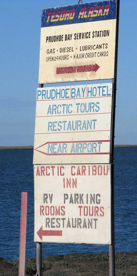
There are no public outhouses or tent-camping areas. There is no public road access to the Arctic Ocean at Prudhoe Bay, and in order to get to the coast, you must sign up with a tour at the Arctic Caribou Inn. There are security gates operated by the oil companies that block passage out to the Ocean.

But, we’re not here to go to the Arctic Ocean – been there, done that in Barrow, ha! We’re here to see Eiders and Long-tailed Ducks! We did see a few very cool Brants!

We checked out the Caribou Inn and the other “fancy” hotel, and like the Prudhoe Bay Hotel best.

It accommodates mainly oil field workers, but it is clean, comfortable, friendly, and the food is really good! We stopped in here our first time to Deadhorse at about midnight, and met Jo, one of the Managers. The parking lot was full! With guys sitting in pickups with company names printed on the side of the vehicles like; BP, AFC, AIS… all double parked in front of the hotel waiting for other guys who went in to get carry-out food. Jo is a super nice middle-aged gal from Oregon informed us that we could stay for $125/person/night which includes all three meals. There is a community bathroom/shower room for women, and one for the men – showers are an extra $20. Remember to put on shoe covers when you enter any of the “camps” (hotels) – I felt I was back in the surgery suite – because the mud is EVERYWHERE!

Snow buntings we all around the buildings in camp, and I just couldn’t stop watching them. They’re my favorite! We opted to sleep in the truck, but decided to come back here for breakfast or lunch the next day. We drove out to the levee of the Sag River and unloaded our gear, inflated the air mattress and snuggled in for the night.

We parked at the same spot on our second visit in July. It was sunny and 45F, with a strong wind from the North when we went to bed – midnight-ish.

Woke up at around 7am to bright sunny skies and a helicopter flying over with a large crate hanging beneath it.

Andreas Lindvere, an Astonian from Canada was parked in a white van down the levee a little way and he walked over while we were eating breakfast.

What cool guy! He is a high school teacher in Toronto, who converted his van to use vegetable oil instead of gasoline.

In Canada, teachers teach for 4 years at 80% pay, and then get each 5th year off – with full pay! We need to do this in America!!! He spends that year travelling the world. Next year he’s going to S. America. Then he brings back pictures and video interviews with people he meets along the way and shares them with his students. Talk about teaching outside the box! This guy really gets it! We spent quite a bit of time chatting with him – he’s got to be just a phenomenal teacher. I wish I could be a fly on the wall in his classroom.

Dave tried to catch some arctic char, but to no avail just not biting today.
We drove out around Lake Colleen scanning the water for Eiders and found phalaropes! Here are pictures from June and then again in July.


Headed over toward the General Store to get souvenirs and a patch for my backpack and a wooden puzzle of Alaska animals for Tess.

I really want a patch that says “I survived the Haul Road!”, because let me tell you, it is not easy to make it all the way to Deadhorse without blowing out a tire. We saw several cars with blowouts along the way, and in June a motorcyclist wiped out and had to be airlifted to Anchorage. So, as pretty as this part of the world is, it is still ABSOLUTLY IMPERATIVE to remember that this is the end of the world, you’ve got to be careful. So, off to get our “survivor” patches! LOL!

As we drove past the Turboscope Vetco Company we spotted some ducks in the water behind the building and Woohoo!!!! there were both Spectacled and King Eider pairs!


We couldn’t believe our luck!!!! We hung out so long taking pictures, that one of the warehouse guys had to shoo us out of his way so he could work! Oops! Took pictures of the ducks over by the golf ball weather radar ball (lots of male Long-tailed Ducks), and then went to the Prudhoe Hotel for lunch.

One last spin around Lake Colleen, and we had to head back south toward Fairbanks. Gotta teach on Monday morning, you know!

Back south through the Coastal Plain (male long-tail in basic plumage),

North Slope (fox-tails at Galbraith Lake)…

Brooks Range (merlin) …

Boreal Forest (blueberries)…

to our home away from home, UAF. A fantastic trip!


